 Alternative C4 Ketchikan, Alaska Photos Courtesy Gravina-Access Project Published:
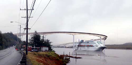
Alternative C4 is a bridge that would span Tongass Narrows approximately 500 meters (1,600 feet) north of the airport terminal. The main span of the bridge would have a vertical clearance of 61 meters (200 feet) and a horizontal clearance of approximately 198 meters (650 feet). The vertical and horizontal clearances of the main span would allow for one-way passage of cruise ships and two-way passage for most other ships, including state ferries, under the bridge. The bridge would connect to Tongass Avenue north of Cambria Drive and would continue northward, traversing the hillside around the quarry, crossing over Tongass Avenue and Tongass Narrows, and then turning southward to parallel the airport runway, and touch down south of the terminal. An airport return loop road would connect the terminal to the bridge. The road would continue around the south end of the airport runway and then arc northward, extending parallel to and west of the airport runway approximately 3.5 kilometers (2.2 miles) to the north end of the Airport Reserve property. The road at the south end of the runway would be constructed at a grade low enough to allow for future runway expansion plans; i.e., the runway would be expanded as an overpass of the road. The EIS is assessing the no-action alternative and nine build alternatives:
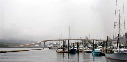   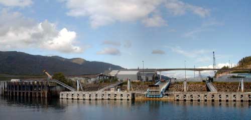
Photo Essay 1 - East Channel High Bridge - Alternative F1 a combined 200-foot high/120-foot high bridge crossing that incorporates Pennock Island (published March 02, 2003) Photo Essay 2 - Alternative F3 Pennock Island Crossing 60-foot High Bridge East Channel and 200-foot High Bridge West Channel Photo Essay 3 - Alternative C3A Photo Essay 4 - Alternative C3B Photo Essay 5 - Alternative C4: 200-foot High Bridge Airport Area to Cambria Drive Area Photo Essay 6 - Alternative D1: 120-foot High Bridge Airport Area Ferry Alternatives: (Alternatives G2, G3, and G4)
A special thank you to the Gravina Access Project Team for providing these photographs & information.
Source of Information:
|